Watauga River
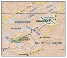
River in the United States of AmericaThe Watauga River is a large stream of western North Carolina and East Tennessee. It is 78.5 miles (126.3 km) long with its headwaters in Linville Gap to the South Fork Holston River at Boone Lake.
Read article
Top Questions
AI generatedMore questions
Nearby Places
Oak Grove, Washington County, Tennessee
CDP in Tennessee, United States
Spurgeon, Tennessee
CDP in Tennessee, United States

Tri-Cities Regional Airport
Airport in Tennessee, U.S.
WHGG
Radio station in Kingsport, Tennessee
WPWT
Radio station in Colonial Heights, Tennessee
Boone Lake
Reservoir in Tennessee, United States

Boone Dam
Dam in Tennessee, United States
Boring, Tennessee
Unincorporated community in Tennessee, US


